Cape Elizabeth
Edit SpotAbout
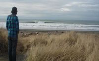
Do not trespass. Respect the Quinault Nation as you would when going to any other country. They used to give day permits but because of disrespect the beaches are now closed.
Additional Info:
Be careful because the surrounding land is tribal land...park your car accordingly. Also you can use satelite photos (flashearth.com) to figure out exactly how to get there. This spot has been protected and hidden for years...but no more secrets. Seek and ye shall find.
Location
Loading...Access
Stay clear. This is on the Quinault Indian Nation beach. Beaches are closed to non-tribal persons. If you choose to venture here and get caught-be prepared to loose your board and possibly your vehicle.
| Walk | Long walk (>30 min) |
|---|---|
| Public access | Yes |
| 4x4 required | No |
| Boat required | Yes |
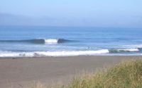
Wave Characteristics
| Type | Reef (rocky) |
|---|---|
| Direction | Right and left |
| Bottom | Reef (coral, sharp rocks etc.) with sand |
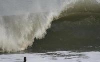
| Power | Hollow, Powerful |
| Frequency | Regular (100 days/year) |
| Normal length | Long (150 to 300m) |
| Good day length | Normal (50 to 150m) |
Ideal Conditions
| Wind direction | North, SouthEast, East |
|---|---|
| Swell direction | NorthWest, West, SouthWest |
| Swell size | 5ft-6ft - 16ft and over |
| Tide | All tides |
| Tide movement | Rising tide |
Crowd
| Week | Empty |
|---|---|
| Weekend | Empty |
Dangers
Rocks
Videos
None
Nearby spots
Point Grenville
6.38 miles away
| Direction: | Right and left |
| Bottom: | Sandy with rock |
| Frequency: | Regular (100 days/year) |
The Cape
27.06 miles away
| Direction: | Right |
| Bottom: | Reef (coral, sharp rocks etc.) |
| Frequency: | Sometimes breaks (50 days/year) |