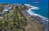
Yellow Patch
Edit SpotAbout
Make the trip when the swell is running.
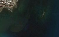
Location
Loading...Access
Catch the ferry to Morton Island and drive noth along the beach over the headland where the light house is.
| Walk | Short walk (5-15 min) |
|---|---|
| Public access | Yes |
| 4x4 required | Yes |
| Boat required | No |
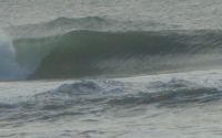
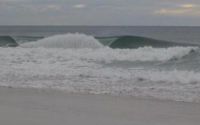
Wave Characteristics
| Type | Point break |
|---|---|
| Direction | Right |
| Bottom | Sandy |
| Power | Fast |
| Frequency | Regular (100 days/year) |
| Normal length | Normal (50 to 150m) |
| Good day length | Very Long (300 to 500m) |
Ideal Conditions
| Wind direction | SouthWest, South |
|---|---|
| Swell direction | SouthEast, East |
| Swell size | Less than 3ft - 10ft+ |
| Tide | All tides |
| Tide movement | Rising and falling tides |
Crowd
| Week | Empty |
|---|---|
| Weekend | Few surfers |
Dangers
Urchins, Rips / undertow, Rocks, Sharks
Videos
None
Nearby spots
Bribie Island
15.85 miles away
| Direction: | Right and left |
| Bottom: | Sandy |
| Frequency: | Sometimes breaks (50 days/year) |

kings beach break
23.57 miles away
| Direction: | Right and left |
| Bottom: | Sandy with rock |
| Frequency: | Very consistent (150+ days/year) |
Kings Beach reef
24.35 miles away
| Direction: | Right and left |
| Bottom: | Reef (coral, sharp rocks etc.) |
| Frequency: | Sometimes breaks (50 days/year) |